Neighborhood Services Division
118 W. Central Ave.
Arkansas City, KS 67005
(620) 441-4420
Geographic Information Systems
GIS stands for Geographic Information Systems or in some cases the S is for Science. What is GIS? you may ask. ESRI, the leading GIS software vendor, provides the following answer:
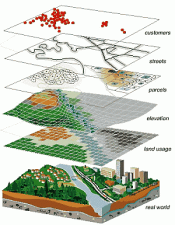
A GIS (Geographic Information System) gives you tools to answer questions about a location (geographic information). You can combine layers of information stored in a database that may include addresses, aerial photographs, satellite images, dates, and other numerical values.
A GIS does more than tell you "where," but can also answer questions like "why" and "what if?" With a GIS, you can explore relationships, trends, and conduct analyses that can be represented as maps.
GIS can be applied to a variety of topics in physical and social sciences, as well as mathematics and art/design, providing a great foundation for interdisciplinary projects. Working with GIS helps students develop computer literacy, analytical approaches to problem-solving, and communication and presentation skills.
The City of Arkansas City has developed a robust GIS. You can now view a webmap by clicking the link below. GIS is also used extensively in the Neighborhood Services Division to facilitate daily operations. Other departments also request maps from information in the GIS.
There are a number of maps available to the general public. If you do not see what you are looking for, fill out a Map Request Form and take it to the Neighborhood Services Office on the 2nd Floor of City Hall.
You can also email your map request form to Josh White and call if you have any questions.

